Original: $41.53
-65%$41.53
$14.54The Story
Physical & Political Detail | Shaded Relief | Premium Finishes
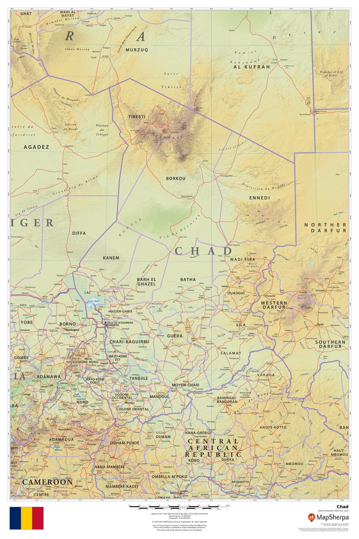
Discover the dramatic landscapes of Chad—from the soaring Tibesti Mountains and sculpted Ennedi Plateau to the vast Sahara and the life-giving waters of Lake Chad. This elegant wall map balances physical terrain with clear political boundaries, showcasing major cities, transport corridors, rivers, and protected areas with crisp, legible cartography.
🗺️ Features & Highlights
-
Balanced Physical & Political Coverage: Clearly marked national and regional boundaries, departments, cities and towns including N’Djamena, Moundou, Sarh, Abéché, and Faya-Largeau.
-
Terrain at a Glance: Shaded relief and color-by-elevation reveal mountain massifs, desert basins, wadis, and plateaus.
-
Hydrology & Corridors: Rivers and seasonal waterways, the Chari–Logone system, and the ecological expanse around Lake Chad.
-
Contextual Geography: Useful regional view with neighboring Libya, Sudan, Central African Republic, Cameroon, Nigeria, and Niger for orientation and planning.
-
Clean, Readable Labels: Thoughtful typography and symbol design for study, planning, or display.
✨ Available Finishes
| Format | Description |
|---|---|
| 📜 Paper (160 gsm) | Heavyweight matte-coated paper—perfect for framing under glass. |
| 🧼 Laminated (Encapsulated) | Fully sealed in 80-micron gloss laminate—durable, wipe-clean, classroom-ready. |
| 🪵 Laminated with Wooden Hang Rails | Laminated map mounted with lacquered natural timber rails (top & bottom) and a hanging cord—ready to hang. |
| 🖼️ Canvas (395 gsm) | HP Professional Matte Canvas with archival pigment inks—rich texture, fade-resistant, gallery quality. |
| 🪵 Canvas with Wooden Hang Rails | Canvas mounted with timber rails and hanging cord—timeless, ready-to-display finish (no frame required). |
🔨 Note: Hang-railed maps are custom mounted—please allow up to 10 working days.
📐 Specifications
| Feature | Detail |
|---|---|
| Title | Chad Wall Map |
| Map Type | Physical / Political |
| Scale | 1:3,000,000 |
| Dimensions | 610 mm (W) × 914 mm (H) |
| Materials | Paper, Laminated, Canvas, with or without Timber Rails |
| Printing | Pigment-based, fade-resistant inks |
| Made In | Australia |
🎁 Perfect For
-
Homes & Offices: A striking focal piece with elegant terrain detail.
-
Classrooms & Libraries: Durable finishes for frequent reference.
-
Fieldwork & Planning: Clear routes, settlements, and landforms at a practical scale.
-
Collectors & Map Lovers: Premium build that blends beauty and accuracy.
🚚 Delivery
-
Paper, Laminated, Canvas (rolled): Typically ship within 1–2 business days.
-
Hang-Railed Maps: Made to order—please allow up to 10 working days.
-
Protective Packaging: Securely packed to arrive in perfect condition.
Bring Chad’s deserts, mountains, rivers, and cities to life on your wall—choose your finish and add to cart today.
Description
Physical & Political Detail | Shaded Relief | Premium Finishes
Discover the dramatic landscapes of Chad—from the soaring Tibesti Mountains and sculpted Ennedi Plateau to the vast Sahara and the life-giving waters of Lake Chad. This elegant wall map balances physical terrain with clear political boundaries, showcasing major cities, transport corridors, rivers, and protected areas with crisp, legible cartography.
🗺️ Features & Highlights
-
Balanced Physical & Political Coverage: Clearly marked national and regional boundaries, departments, cities and towns including N’Djamena, Moundou, Sarh, Abéché, and Faya-Largeau.
-
Terrain at a Glance: Shaded relief and color-by-elevation reveal mountain massifs, desert basins, wadis, and plateaus.
-
Hydrology & Corridors: Rivers and seasonal waterways, the Chari–Logone system, and the ecological expanse around Lake Chad.
-
Contextual Geography: Useful regional view with neighboring Libya, Sudan, Central African Republic, Cameroon, Nigeria, and Niger for orientation and planning.
-
Clean, Readable Labels: Thoughtful typography and symbol design for study, planning, or display.
✨ Available Finishes
| Format | Description |
|---|---|
| 📜 Paper (160 gsm) | Heavyweight matte-coated paper—perfect for framing under glass. |
| 🧼 Laminated (Encapsulated) | Fully sealed in 80-micron gloss laminate—durable, wipe-clean, classroom-ready. |
| 🪵 Laminated with Wooden Hang Rails | Laminated map mounted with lacquered natural timber rails (top & bottom) and a hanging cord—ready to hang. |
| 🖼️ Canvas (395 gsm) | HP Professional Matte Canvas with archival pigment inks—rich texture, fade-resistant, gallery quality. |
| 🪵 Canvas with Wooden Hang Rails | Canvas mounted with timber rails and hanging cord—timeless, ready-to-display finish (no frame required). |
🔨 Note: Hang-railed maps are custom mounted—please allow up to 10 working days.
📐 Specifications
| Feature | Detail |
|---|---|
| Title | Chad Wall Map |
| Map Type | Physical / Political |
| Scale | 1:3,000,000 |
| Dimensions | 610 mm (W) × 914 mm (H) |
| Materials | Paper, Laminated, Canvas, with or without Timber Rails |
| Printing | Pigment-based, fade-resistant inks |
| Made In | Australia |
🎁 Perfect For
-
Homes & Offices: A striking focal piece with elegant terrain detail.
-
Classrooms & Libraries: Durable finishes for frequent reference.
-
Fieldwork & Planning: Clear routes, settlements, and landforms at a practical scale.
-
Collectors & Map Lovers: Premium build that blends beauty and accuracy.
🚚 Delivery
-
Paper, Laminated, Canvas (rolled): Typically ship within 1–2 business days.
-
Hang-Railed Maps: Made to order—please allow up to 10 working days.
-
Protective Packaging: Securely packed to arrive in perfect condition.
Bring Chad’s deserts, mountains, rivers, and cities to life on your wall—choose your finish and add to cart today.