✨ New Arrivals Just Dropped!Explore
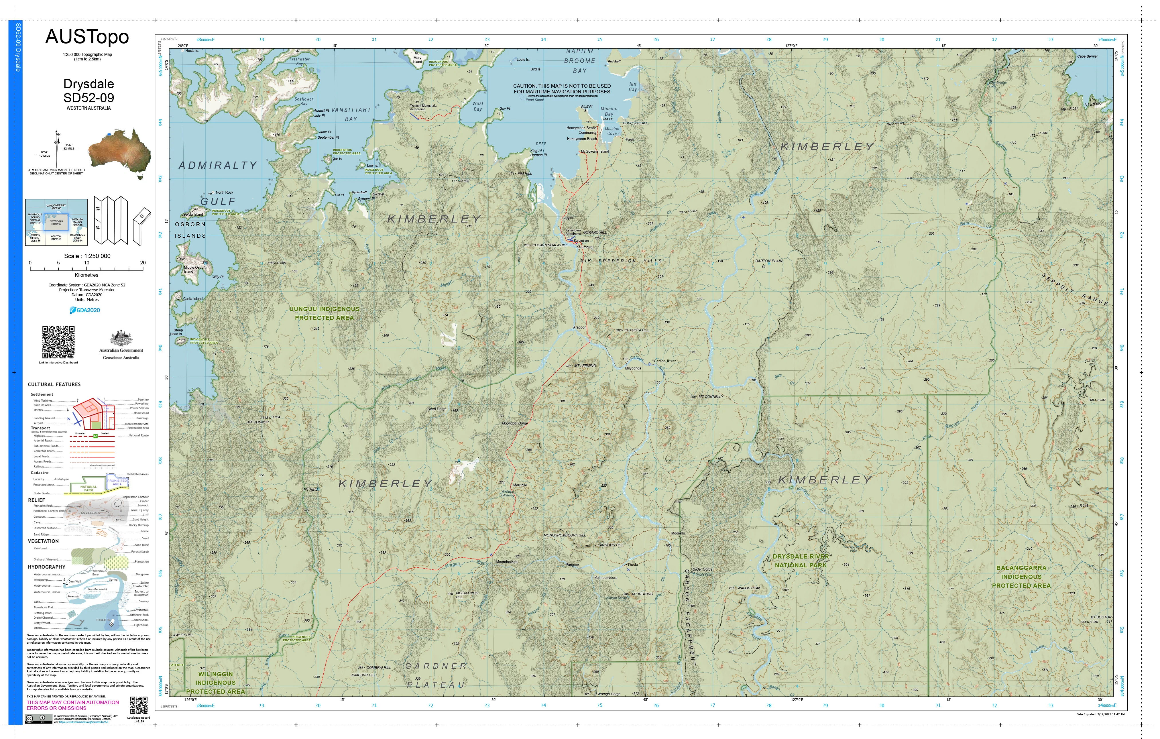
Drysdale D5209 AUSTopo 1:250,000 Map
HomeStore

Drysdale D5209 AUSTopo 1:250,000 Map

Drysdale D5209 AUSTopo 1:250,000 Map

Select Finish
From $4.84

Original: $13.82

-65%
Drysdale D5209 AUSTopo 1:250,000 Map

$13.82

$4.84

The Story

Drysdale D5209 — AUSTopo 1:250,000 Topographic Map (2025)

Rugged Kimberley ranges, mighty river systems, and the wild north-east coast—mapped with authority and continental scale

Covering the Drysdale River and the north-east Kimberley of Western Australia, this AUSTopo 1:250,000 sheet delivers a clear, authoritative regional overview of one of Australia’s most dramatic and remote landscapes. From towering sandstone plateaux and deep gorges to mangrove-lined estuaries, islands, and coral-fringed coastline, it provides essential big-picture context for land management, expedition planning, and serious remote-area operations.

At 1:250,000 scale (1 cm = 2.5 km), this is the largest scale at which published topographic maps cover the entire Australian continent—ideal for regional planning, environmental and cultural land management, emergency coordination, and professional field use.


🧭 Why this map stands out

  • Updated mapping (2025) — aligned to modern Australian datums for confident, current use

  • True plateau-to-reef perspective — ranges, rivers, and coastal waters shown in one coherent view

  • Professional-grade cartography — relied on by emergency services, rangers, and land managers

  • Dual coordinate systems — seamless transition between office planning and field navigation

  • Printed in Australia — precision output, locally finished and quality-checked


🗺️ What you’ll see

  • Contours and spot elevations across sandstone ranges and coastal plains

  • Major rivers, estuaries, reefs, islands, and tidal flats

  • Tracks, airstrips, coastal features, and place names

  • Vegetation patterns and administrative / land-use boundaries

  • Clear grid overlays for accurate positioning and regional planning


📐 Map details at a glance

  • Scale: 1:250,000

  • Series: AUSTopo — Australian Digital Topographic Map Series

  • Coverage: Drysdale D5209

  • Map currency: 2025

  • Coordinates: Geographical & MGA

  • Datum: GDA2020, AHD

  • Projection: Universal Transverse Mercator (UTM)

  • Sheet size: 800 mm (W) × 500 mm (H)


🎨 Field-ready print options

All finishes are printed in Australia using high-resolution colour for crisp linework and dependable legibility.

  • 📄 Paper (standard) — ideal for planning tables, offices, classrooms, or framed Kimberley reference.

  • 💧 DuPont™ Tyvek® (waterproof & tear-proof) — foldable, lightweight, and exceptionally durable for tropical, riverine, and wet-season fieldwork.

  • 🔒 Laminated (write-on / wipe-off) — true encapsulation; annotate routes, reef zones, or survey areas with whiteboard markers or apply map dots, then wipe clean.


🎯 Who it’s for

  • Emergency services & remote-area coordinators

  • Indigenous land councils & ranger groups

  • Environmental & marine managers

  • Educators, students & researchers

  • Kimberley explorers and expedition planners


🇦🇺 Our commitment

Every AUSTopo map we supply is printed and finished in Australia, colour-managed for accuracy, hand-checked, and packed with care—so it arrives ready for real-world use.

Plan, manage, and explore the Drysdale region with confidence. Choose your finish and add this essential 2025 AUSTopo map to your kit today.

Description

Drysdale D5209 — AUSTopo 1:250,000 Topographic Map (2025)

Rugged Kimberley ranges, mighty river systems, and the wild north-east coast—mapped with authority and continental scale

Covering the Drysdale River and the north-east Kimberley of Western Australia, this AUSTopo 1:250,000 sheet delivers a clear, authoritative regional overview of one of Australia’s most dramatic and remote landscapes. From towering sandstone plateaux and deep gorges to mangrove-lined estuaries, islands, and coral-fringed coastline, it provides essential big-picture context for land management, expedition planning, and serious remote-area operations.

At 1:250,000 scale (1 cm = 2.5 km), this is the largest scale at which published topographic maps cover the entire Australian continent—ideal for regional planning, environmental and cultural land management, emergency coordination, and professional field use.


🧭 Why this map stands out

  • Updated mapping (2025) — aligned to modern Australian datums for confident, current use

  • True plateau-to-reef perspective — ranges, rivers, and coastal waters shown in one coherent view

  • Professional-grade cartography — relied on by emergency services, rangers, and land managers

  • Dual coordinate systems — seamless transition between office planning and field navigation

  • Printed in Australia — precision output, locally finished and quality-checked


🗺️ What you’ll see

  • Contours and spot elevations across sandstone ranges and coastal plains

  • Major rivers, estuaries, reefs, islands, and tidal flats

  • Tracks, airstrips, coastal features, and place names

  • Vegetation patterns and administrative / land-use boundaries

  • Clear grid overlays for accurate positioning and regional planning


📐 Map details at a glance

  • Scale: 1:250,000

  • Series: AUSTopo — Australian Digital Topographic Map Series

  • Coverage: Drysdale D5209

  • Map currency: 2025

  • Coordinates: Geographical & MGA

  • Datum: GDA2020, AHD

  • Projection: Universal Transverse Mercator (UTM)

  • Sheet size: 800 mm (W) × 500 mm (H)


🎨 Field-ready print options

All finishes are printed in Australia using high-resolution colour for crisp linework and dependable legibility.

  • 📄 Paper (standard) — ideal for planning tables, offices, classrooms, or framed Kimberley reference.

  • 💧 DuPont™ Tyvek® (waterproof & tear-proof) — foldable, lightweight, and exceptionally durable for tropical, riverine, and wet-season fieldwork.

  • 🔒 Laminated (write-on / wipe-off) — true encapsulation; annotate routes, reef zones, or survey areas with whiteboard markers or apply map dots, then wipe clean.


🎯 Who it’s for

  • Emergency services & remote-area coordinators

  • Indigenous land councils & ranger groups

  • Environmental & marine managers

  • Educators, students & researchers

  • Kimberley explorers and expedition planners


🇦🇺 Our commitment

Every AUSTopo map we supply is printed and finished in Australia, colour-managed for accuracy, hand-checked, and packed with care—so it arrives ready for real-world use.

Plan, manage, and explore the Drysdale region with confidence. Choose your finish and add this essential 2025 AUSTopo map to your kit today.

You may also like

NEW
Thumbnail 1Thumbnail 2

Mornington Island Special E5401 AUSTopo 1:250,000 Map

$13.82

NEW
Thumbnail 1Thumbnail 2

Westmoreland E5405 AUSTopo 1:250,000 Map

$13.82

-65%NEW
Thumbnail 1Thumbnail 2

Camooweal E5413 AUSTopo 1:250,000 Map

$13.82

$4.84

-65%NEW
Thumbnail 1Thumbnail 2

Lawn Hill E5409 AUSTopo 1:250,000 Map

$13.82

$4.84

-65%NEW
Thumbnail 1Thumbnail 2

Mount Isa F5401 AUSTopo 1:250,000 Map

$13.82

$4.84

-65%NEW
Thumbnail 1Thumbnail 2

Donors Hill E5410 AUSTopo 1:250,000 Map

$13.82

$4.84

-65%NEW
Thumbnail 1Thumbnail 2

Burra I5405 AUSTopo 1:250,000 Map

$13.82

$4.84

-65%NEW
Thumbnail 1Thumbnail 2

Burketown E5406 AUSTopo 1:250,000 Map

$13.82

$4.84

-65%NEW
Thumbnail 1Thumbnail 2

Barker I5413 AUSTopo 1:250,000 Map

$13.82

$4.84

-65%NEW
Thumbnail 1Thumbnail 2

Parachilna H5413 AUSTopo 1:250,000 Map

$13.82

$4.84

-65%NEW
Thumbnail 1Thumbnail 2

Copley H5409 AUSTopo 1:250,000 Map

$13.82

$4.84

-65%NEW
Thumbnail 1Thumbnail 2

Orroroo I5401 AUSTopo 1:250,000 Map

$13.82

$4.84