✨ New Arrivals Just Dropped!Explore
New South Wales Local Government Areas Wall Map
HomeStore

New South Wales Local Government Areas Wall Map

New South Wales Local Government Areas Wall Map

Select Finish
From $16.96

Original: $48.45

-65%
New South Wales Local Government Areas Wall Map

$48.45

$16.96

The Story

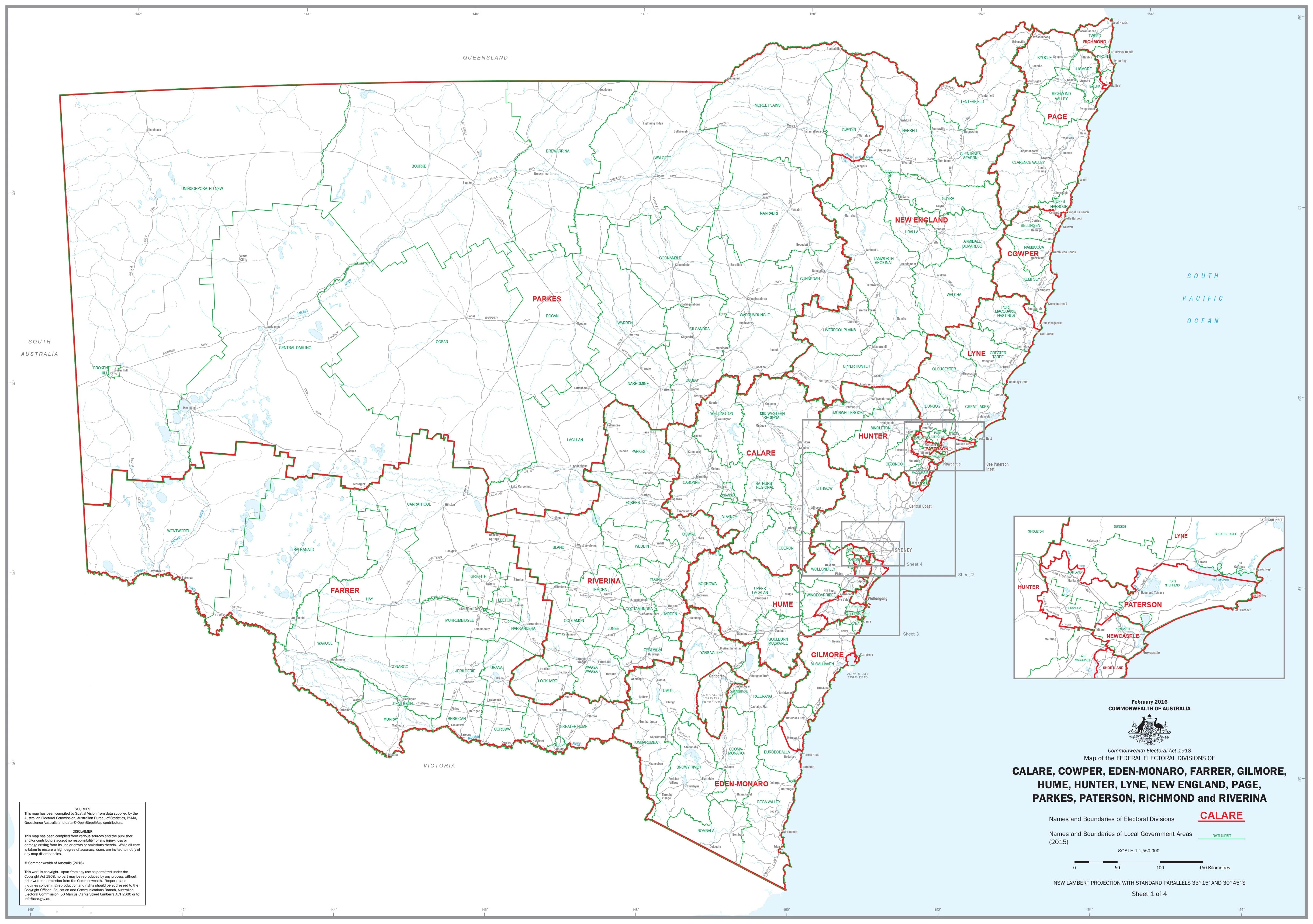
New South Wales Local Government Areas — Administrative Wall Map

1000 × 540 mm • Paper / Laminated / Laminated + Hang Rails / Canvas / Canvas + Hang Rails • Printed in Australia

A clear, wall-readable reference of every Local Government Area (LGA) in New South Wales—purpose-built for offices, classrooms, and planning spaces where boundaries and place-names need to be read at a glance.


🧭 At a Glance (What’s on the Map)

  • All NSW LGA boundaries & names with clean hierarchy

  • Legend, scale bar & neatline for quick orientation

  • Statewide context—see each LGA in relation to NSW

  • Wall-readable labelling—clear fonts sized for meeting-room distance

  • Context labels—adjoining states and major waterbodies


🎯 Why This Map Works

  • Made for discussion — instantly identify LGAs for coverage, funding, and compliance conversations

  • Planning-ready — ideal for territory alignment, asset deployment, sales/service zones, community engagement

  • Meeting-proof clarity — crisp boundary styling and uncluttered labels hold up across the room

  • Durable finishes — choose hard-wearing laminate for daily use or canvas for a premium display


👥 Who Uses It

  • Local & State Government — councillor briefings, planning, consultations

  • Utilities & Logistics — outage maps, last-mile planning, contractor coordination

  • Healthcare & Education — catchments and school zones (overlay with your data)

  • Real Estate & Media — marketing territories, reporting regions

  • Libraries & Community Centres — public reference & display


🧩 Design Details (Readability & Clarity)

  • Boundary hierarchy — LGA outlines emphasised; state boundary subtly reinforced

  • Labelling strategy — high-contrast, legible typography for wall viewing

  • Balanced palette — separates areas without visual noise

  • Cartographic consistency — neatline, scale bar, legend aligned for quick teaching moments


🎨 Finishes & Display Options

  • 📄 Paper — Heavyweight 160 gsm (Matte)
    Smooth, low-glare stock ideal for framing under glass.

  • 💧 Laminated — True Encapsulation
    Printed on 120 gsm and sealed in 2 × 80-micron gloss laminate (edge-sealed).
    Wipe-clean • Tear-resistant • Moisture-safe — use non-permanent whiteboard markers and map dots.

  • 🪵 Laminated + Timber Hang Rails — Ready to Hang
    Natural lacquered timber rails (top & bottom) with a top hanging cord for a clean, frame-free display.
    ⏱️ Custom finish — please allow up to 10 working days for rail fitting.

  • 🖼️ Canvas — HP 395 gsm Professional Matte
    Gallery-grade canvas with pigment-based, fade-resistant inks for rich, long-life colour.

  • 🪵 Canvas + Timber Hang Rails
    Same premium canvas, finished with natural timber rails + top hanging cordready to hang.
    ⏱️ Custom finish — please allow up to 10 working days for rail fitting.

Dry-erase markers are recommended only on laminated versions.


🛠️ Practical Uses & Workshop Ideas

  • Territory Tune-Up: Mark current service areas; rebalance LGA groupings.

  • Community Coverage: Overlay program sites vs. LGA population to spot gaps.

  • Rapid Response: Use laminated version for outage/weather/event coordination and quick annotations.

  • Reporting Wall: Pin reports or QR codes by LGA to centralise updates.


📐 Specifications

Attribute Details
Title New South Wales Local Government Areas — Administrative Wall Map
Coverage State of New South Wales, Australia
Map Type Administrative (Local Government Areas)
Size 1000 mm (W) × 540 mm (H)
Scale Not stated
Formats Paper • Laminated • Laminated + Hang Rails • Canvas • Canvas + Hang Rails
Paper 160 gsm matte
Laminate 2 × 80-micron gloss, true encapsulation (edge-sealed)
Canvas HP 395 gsm Professional Matte
Inks Pigment-based, fade-resistant
Origin Printed in Australia
Lead Time Hang-railed finishes: up to 10 working days

🧽 Mounting & Care

  • Laminated: Use non-permanent whiteboard markers; wipe with a dry microfibre cloth (lightly damp if needed).

  • Paper: Frame under glass for longevity; avoid direct sunlight.

  • Canvas: Dust gently; avoid liquids and prolonged direct sunlight.

  • Hanging tip: For rails, use a centred wall hook; let the map hang naturally.


🤝 Our Commitment

  • Local craftsmanship: Designed, printed, and finished in Australia.

  • Quality materials: Archival pigment inks and premium stocks for long service life.

  • Packed with care: Hand-checked and securely boxed to arrive clean and display-ready.


Clarify NSW’s LGA landscape at a glance.
Choose your finish, add to cart, and put accurate boundaries on the wall.

Description

New South Wales Local Government Areas — Administrative Wall Map

1000 × 540 mm • Paper / Laminated / Laminated + Hang Rails / Canvas / Canvas + Hang Rails • Printed in Australia

A clear, wall-readable reference of every Local Government Area (LGA) in New South Wales—purpose-built for offices, classrooms, and planning spaces where boundaries and place-names need to be read at a glance.


🧭 At a Glance (What’s on the Map)

  • All NSW LGA boundaries & names with clean hierarchy

  • Legend, scale bar & neatline for quick orientation

  • Statewide context—see each LGA in relation to NSW

  • Wall-readable labelling—clear fonts sized for meeting-room distance

  • Context labels—adjoining states and major waterbodies


🎯 Why This Map Works

  • Made for discussion — instantly identify LGAs for coverage, funding, and compliance conversations

  • Planning-ready — ideal for territory alignment, asset deployment, sales/service zones, community engagement

  • Meeting-proof clarity — crisp boundary styling and uncluttered labels hold up across the room

  • Durable finishes — choose hard-wearing laminate for daily use or canvas for a premium display


👥 Who Uses It

  • Local & State Government — councillor briefings, planning, consultations

  • Utilities & Logistics — outage maps, last-mile planning, contractor coordination

  • Healthcare & Education — catchments and school zones (overlay with your data)

  • Real Estate & Media — marketing territories, reporting regions

  • Libraries & Community Centres — public reference & display


🧩 Design Details (Readability & Clarity)

  • Boundary hierarchy — LGA outlines emphasised; state boundary subtly reinforced

  • Labelling strategy — high-contrast, legible typography for wall viewing

  • Balanced palette — separates areas without visual noise

  • Cartographic consistency — neatline, scale bar, legend aligned for quick teaching moments


🎨 Finishes & Display Options

  • 📄 Paper — Heavyweight 160 gsm (Matte)
    Smooth, low-glare stock ideal for framing under glass.

  • 💧 Laminated — True Encapsulation
    Printed on 120 gsm and sealed in 2 × 80-micron gloss laminate (edge-sealed).
    Wipe-clean • Tear-resistant • Moisture-safe — use non-permanent whiteboard markers and map dots.

  • 🪵 Laminated + Timber Hang Rails — Ready to Hang
    Natural lacquered timber rails (top & bottom) with a top hanging cord for a clean, frame-free display.
    ⏱️ Custom finish — please allow up to 10 working days for rail fitting.

  • 🖼️ Canvas — HP 395 gsm Professional Matte
    Gallery-grade canvas with pigment-based, fade-resistant inks for rich, long-life colour.

  • 🪵 Canvas + Timber Hang Rails
    Same premium canvas, finished with natural timber rails + top hanging cordready to hang.
    ⏱️ Custom finish — please allow up to 10 working days for rail fitting.

Dry-erase markers are recommended only on laminated versions.


🛠️ Practical Uses & Workshop Ideas

  • Territory Tune-Up: Mark current service areas; rebalance LGA groupings.

  • Community Coverage: Overlay program sites vs. LGA population to spot gaps.

  • Rapid Response: Use laminated version for outage/weather/event coordination and quick annotations.

  • Reporting Wall: Pin reports or QR codes by LGA to centralise updates.


📐 Specifications

Attribute Details
Title New South Wales Local Government Areas — Administrative Wall Map
Coverage State of New South Wales, Australia
Map Type Administrative (Local Government Areas)
Size 1000 mm (W) × 540 mm (H)
Scale Not stated
Formats Paper • Laminated • Laminated + Hang Rails • Canvas • Canvas + Hang Rails
Paper 160 gsm matte
Laminate 2 × 80-micron gloss, true encapsulation (edge-sealed)
Canvas HP 395 gsm Professional Matte
Inks Pigment-based, fade-resistant
Origin Printed in Australia
Lead Time Hang-railed finishes: up to 10 working days

🧽 Mounting & Care

  • Laminated: Use non-permanent whiteboard markers; wipe with a dry microfibre cloth (lightly damp if needed).

  • Paper: Frame under glass for longevity; avoid direct sunlight.

  • Canvas: Dust gently; avoid liquids and prolonged direct sunlight.

  • Hanging tip: For rails, use a centred wall hook; let the map hang naturally.


🤝 Our Commitment

  • Local craftsmanship: Designed, printed, and finished in Australia.

  • Quality materials: Archival pigment inks and premium stocks for long service life.

  • Packed with care: Hand-checked and securely boxed to arrive clean and display-ready.


Clarify NSW’s LGA landscape at a glance.
Choose your finish, add to cart, and put accurate boundaries on the wall.