Original: $13.82
-65%$13.82
$4.84The Story
🗺️ North East Tasmania Map – TASMAP 1:250,000 Regional Series
Explore the quiet beauty and winding backroads of Tasmania’s northeast
The North East Tasmania Map by TASMAP is part of a high-quality four-map series that together cover the entire island of Tasmania, including insets for Macquarie Island and King Island. This specific sheet focuses on the northeast corner of Tasmania — a region renowned for its rugged coastlines, temperate rainforests, rich farming country, and quiet, winding inland roads.
Covering approximately 37,000 square kilometres, this map is perfect for travellers, cyclists, regional planners, and locals looking to explore beyond Tasmania’s main tourist routes. With its precise detail and topographic representation, this is a must-have for those seeking a deeper understanding of the region’s landscape, roads, and communities.
📍 Regional Coverage Includes:
-
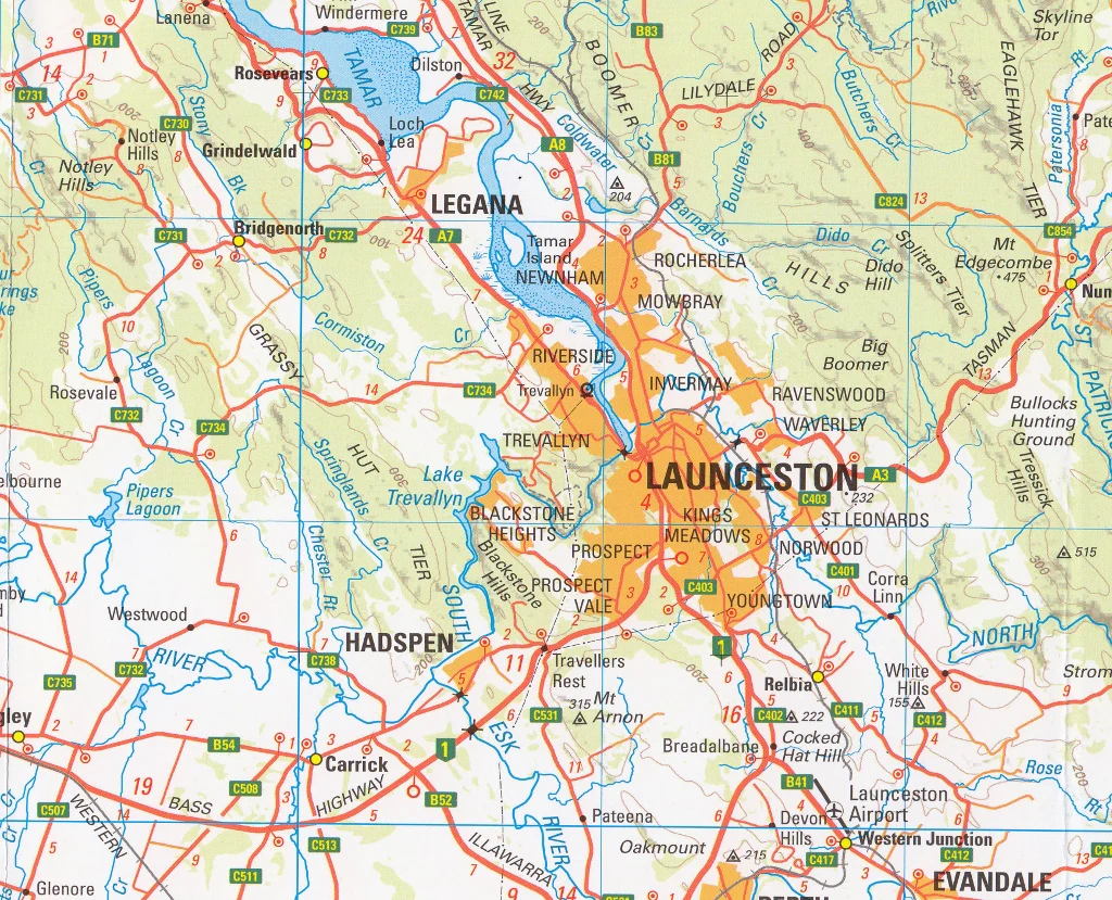
Launceston, George Town, and the Tamar Valley
-
Scottsdale, Branxholm, and Derby – gateway to Blue Derby MTB trails
-
St Helens and the stunning Bay of Fires coastline
-
Ben Lomond National Park and alpine highlands
-
Eddystone Point, Bridport, Lilydale, and inland farming communities
🧭 Key Map Features
✅ Scale: 1:250,000
A balanced scale ideal for both regional overview and road-by-road navigation
✅ Road Network Classification
-
Roads are symbolised by surface type (sealed, unsealed) and importance in the state network
-
Distance markers included between towns and major intersections for easy trip planning
✅ Topographic Detail
-
Contours at 100-metre intervals to represent elevation and terrain
-
Enhanced with hypsometric tinting and hillshading to visually depict the shape of the land
-
Excellent for understanding terrain – perfect for cyclists, planners, and environmental mapping
✅ Inset Maps
Each map in the series includes smaller insets of Macquarie Island and King Island, providing full coverage of Tasmania and its offshore territories
✅ Points of Interest
-
National parks and nature reserves
-
Tourist attractions and scenic drives
-
Walking tracks and recreation areas
-
Towns, hamlets, rivers, and coastline features
📐 Map Specifications
| Feature | Details |
|---|---|
| Title | North East Tasmania – TASMAP |
| Series | 1:250,000 Regional Map Series |
| Coverage | NE Tasmania + Insets (Macquarie & King Islands) |
| Scale | 1:250,000 |
| Contours | 100-metre vertical intervals |
| Map Size | Standard folded map (full-size unfolded sheet) |
| Publisher | TASMAP (Department of Natural Resources & Environment Tasmania) |
| Edition | Latest edition available |
| Material | Premium-grade paper (optional lamination available) |
| Printed in | Australia |
🎯 Ideal For:
-
🚗 Regional travellers and road trippers
-
🚴♂️ Cyclists and mountain bikers exploring backroads and trail networks
-
🏞️ Hikers, bushwalkers, and national park explorers
-
🧭 Geographers, researchers, and planners needing terrain analysis
-
🧳 Visitors wanting to escape the tourist crowds and discover hidden gems
🧱 Optional Lamination
We can supply this map fully laminated with 80-micron gloss film, making it:
-
💧 Waterproof and tear-resistant
-
✏️ Writable with whiteboard markers or map dots
-
🛠️ Perfect for fieldwork, 4WD dashboards, or campsite planning tables
🌿 Discover the Real Tasmania
Beyond the brochures and bus tours lies the real Tasmania — rolling hills, lonely beaches, country roads, and proud, self-sufficient communities. Whether you're planning your next cycling adventure, camping in the northeast forests, or simply mapping a drive through this breathtaking region, the TASMAP North East Tasmania Map delivers the detail, accuracy, and durability you need.
Go beyond the highway. Explore the northeast with TASMAP.

Details & Craftsmanship
Every detail has been carefully considered to bring you the perfect product.
Details & Craftsmanship
Every detail has been carefully considered to bring you the perfect product.
Description
🗺️ North East Tasmania Map – TASMAP 1:250,000 Regional Series
Explore the quiet beauty and winding backroads of Tasmania’s northeast
The North East Tasmania Map by TASMAP is part of a high-quality four-map series that together cover the entire island of Tasmania, including insets for Macquarie Island and King Island. This specific sheet focuses on the northeast corner of Tasmania — a region renowned for its rugged coastlines, temperate rainforests, rich farming country, and quiet, winding inland roads.
Covering approximately 37,000 square kilometres, this map is perfect for travellers, cyclists, regional planners, and locals looking to explore beyond Tasmania’s main tourist routes. With its precise detail and topographic representation, this is a must-have for those seeking a deeper understanding of the region’s landscape, roads, and communities.
📍 Regional Coverage Includes:
-
Launceston, George Town, and the Tamar Valley
-
Scottsdale, Branxholm, and Derby – gateway to Blue Derby MTB trails
-
St Helens and the stunning Bay of Fires coastline
-
Ben Lomond National Park and alpine highlands
-
Eddystone Point, Bridport, Lilydale, and inland farming communities
🧭 Key Map Features
✅ Scale: 1:250,000
A balanced scale ideal for both regional overview and road-by-road navigation
✅ Road Network Classification
-
Roads are symbolised by surface type (sealed, unsealed) and importance in the state network
-
Distance markers included between towns and major intersections for easy trip planning
✅ Topographic Detail
-
Contours at 100-metre intervals to represent elevation and terrain
-
Enhanced with hypsometric tinting and hillshading to visually depict the shape of the land
-
Excellent for understanding terrain – perfect for cyclists, planners, and environmental mapping
✅ Inset Maps
Each map in the series includes smaller insets of Macquarie Island and King Island, providing full coverage of Tasmania and its offshore territories
✅ Points of Interest
-
National parks and nature reserves
-
Tourist attractions and scenic drives
-
Walking tracks and recreation areas
-
Towns, hamlets, rivers, and coastline features
📐 Map Specifications
| Feature | Details |
|---|---|
| Title | North East Tasmania – TASMAP |
| Series | 1:250,000 Regional Map Series |
| Coverage | NE Tasmania + Insets (Macquarie & King Islands) |
| Scale | 1:250,000 |
| Contours | 100-metre vertical intervals |
| Map Size | Standard folded map (full-size unfolded sheet) |
| Publisher | TASMAP (Department of Natural Resources & Environment Tasmania) |
| Edition | Latest edition available |
| Material | Premium-grade paper (optional lamination available) |
| Printed in | Australia |
🎯 Ideal For:
-
🚗 Regional travellers and road trippers
-
🚴♂️ Cyclists and mountain bikers exploring backroads and trail networks
-
🏞️ Hikers, bushwalkers, and national park explorers
-
🧭 Geographers, researchers, and planners needing terrain analysis
-
🧳 Visitors wanting to escape the tourist crowds and discover hidden gems
🧱 Optional Lamination
We can supply this map fully laminated with 80-micron gloss film, making it:
-
💧 Waterproof and tear-resistant
-
✏️ Writable with whiteboard markers or map dots
-
🛠️ Perfect for fieldwork, 4WD dashboards, or campsite planning tables
🌿 Discover the Real Tasmania
Beyond the brochures and bus tours lies the real Tasmania — rolling hills, lonely beaches, country roads, and proud, self-sufficient communities. Whether you're planning your next cycling adventure, camping in the northeast forests, or simply mapping a drive through this breathtaking region, the TASMAP North East Tasmania Map delivers the detail, accuracy, and durability you need.
Go beyond the highway. Explore the northeast with TASMAP.