Original: $48.45
-65%$48.45
$16.96The Story
Published: 1935 | Available in 3 Sizes | Paper, Laminated or Canvas Finish
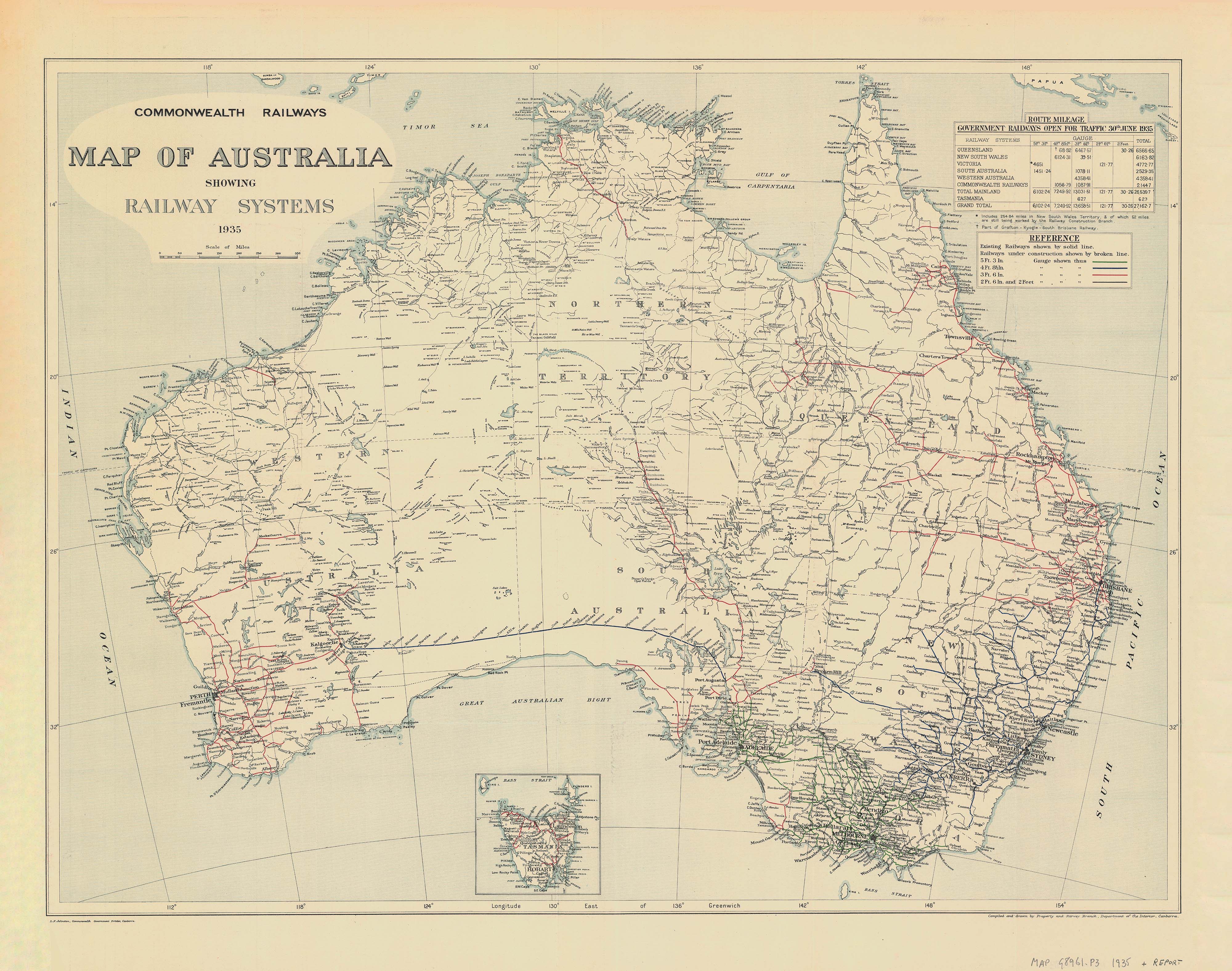
Step back in time with this faithful reproduction of the Commonwealth Railways Map of Australia, originally published on 30 June 1935. A striking historical piece and a fascinating insight into the country’s early railway development, this map vividly displays the government railway networks open to traffic in 1935, with colour-coded lines that reflect the four different railway gauges used across Australia at the time.
A Stunning Piece of Railway History
Authentic 1935 Design
-
Reproduction of the official Commonwealth Railways publication
-
Shows the operational railway lines as of mid-1935
-
Gauge sizes are clearly colour-coded for ease of reference
-
A compelling visual record of Australian infrastructure history
Perfect for Railway Enthusiasts, History Buffs & Collectors
-
Ideal for framing in a study, office, library or man cave
-
Makes a unique and thoughtful gift for transport lovers and heritage aficionados
🖼️ Available Finishes
160gsm Paper Print
-
Ideal for framing under glass
-
Crisp, archival-quality reproduction
-
Matte finish to reduce glare
Laminated (Encapsulated)
-
True encapsulation in 80-micron gloss laminate (front and back)
-
Tear- and stain-resistant
-
Write-on/wipe-off surface—great for educational use
395gsm Matte Canvas (Premium Option)
-
Printed using pigment-based inks on HP Professional Matte Canvas
-
Durable, fade-resistant, and exquisitely detailed
-
Option to add timber hang rails for a ready-to-display vintage look
Optional Timber Hang Rails
-
Lacquered in a natural finish
-
Easy to hang with a cord attached to the top rail
-
Please allow 10 working days for hang rail preparation by our framer
📏 Available Sizes
| Size Label | Dimensions (W x H) |
|---|---|
| Standard | 800 mm x 640 mm |
| Large | 1150 mm x 920 mm |
| Oversize | 1800 mm x 1450 mm |
Select your preferred size and finish from the dropdown menu above.
📦 Product Specifications
| Feature | Details |
|---|---|
| Map Title | Commonwealth Railways Map of Australia |
| Original Date | 30 June 1935 |
| Map Features | Rail networks by gauge, state boundaries |
| Materials | Paper / Laminated / Canvas |
| Print Quality | Archival-grade, fade-resistant inks |
| Canvas Option | HP 395gsm Matte Canvas + Hang Rails (opt.) |
Perfect For:
✔️ Railway historians and collectors
✔️ Home and office décor with a vintage twist
✔️ Education and transport enthusiasts
✔️ Museum displays or heritage centres
This 1935 Vintage Railway Map of Australia offers not just a glimpse into the nation’s transport past but a timeless decorative piece. With multiple sizes and finishes available, including our stunning canvas + hang rail format, this map is both an informative reference and a piece of art that celebrates Australia’s rail heritage in style.
🛒 Add to Cart Today – and bring home a classic piece of Australian cartographic history.
Description
Published: 1935 | Available in 3 Sizes | Paper, Laminated or Canvas Finish
Step back in time with this faithful reproduction of the Commonwealth Railways Map of Australia, originally published on 30 June 1935. A striking historical piece and a fascinating insight into the country’s early railway development, this map vividly displays the government railway networks open to traffic in 1935, with colour-coded lines that reflect the four different railway gauges used across Australia at the time.
A Stunning Piece of Railway History
Authentic 1935 Design
-
Reproduction of the official Commonwealth Railways publication
-
Shows the operational railway lines as of mid-1935
-
Gauge sizes are clearly colour-coded for ease of reference
-
A compelling visual record of Australian infrastructure history
Perfect for Railway Enthusiasts, History Buffs & Collectors
-
Ideal for framing in a study, office, library or man cave
-
Makes a unique and thoughtful gift for transport lovers and heritage aficionados
🖼️ Available Finishes
160gsm Paper Print
-
Ideal for framing under glass
-
Crisp, archival-quality reproduction
-
Matte finish to reduce glare
Laminated (Encapsulated)
-
True encapsulation in 80-micron gloss laminate (front and back)
-
Tear- and stain-resistant
-
Write-on/wipe-off surface—great for educational use
395gsm Matte Canvas (Premium Option)
-
Printed using pigment-based inks on HP Professional Matte Canvas
-
Durable, fade-resistant, and exquisitely detailed
-
Option to add timber hang rails for a ready-to-display vintage look
Optional Timber Hang Rails
-
Lacquered in a natural finish
-
Easy to hang with a cord attached to the top rail
-
Please allow 10 working days for hang rail preparation by our framer
📏 Available Sizes
| Size Label | Dimensions (W x H) |
|---|---|
| Standard | 800 mm x 640 mm |
| Large | 1150 mm x 920 mm |
| Oversize | 1800 mm x 1450 mm |
Select your preferred size and finish from the dropdown menu above.
📦 Product Specifications
| Feature | Details |
|---|---|
| Map Title | Commonwealth Railways Map of Australia |
| Original Date | 30 June 1935 |
| Map Features | Rail networks by gauge, state boundaries |
| Materials | Paper / Laminated / Canvas |
| Print Quality | Archival-grade, fade-resistant inks |
| Canvas Option | HP 395gsm Matte Canvas + Hang Rails (opt.) |
Perfect For:
✔️ Railway historians and collectors
✔️ Home and office décor with a vintage twist
✔️ Education and transport enthusiasts
✔️ Museum displays or heritage centres
This 1935 Vintage Railway Map of Australia offers not just a glimpse into the nation’s transport past but a timeless decorative piece. With multiple sizes and finishes available, including our stunning canvas + hang rail format, this map is both an informative reference and a piece of art that celebrates Australia’s rail heritage in style.
🛒 Add to Cart Today – and bring home a classic piece of Australian cartographic history.